From Andrew Crombie Ramsay 29 December 1858
46 North St. | St Andrews
29 Dec. 1858
My dear Sir
I recd your note late last night, & shall gladly do what I can to help you, for I know you never act without good reason, & make good use of any information that can be given.1
The enormous thickness given to the Cambrian of the Longmynd I more than doubt.2 The beds stand nearly on end, & I suspect them to be doubled up if not more frequently strongly contorted, the tops of the curves being denuded
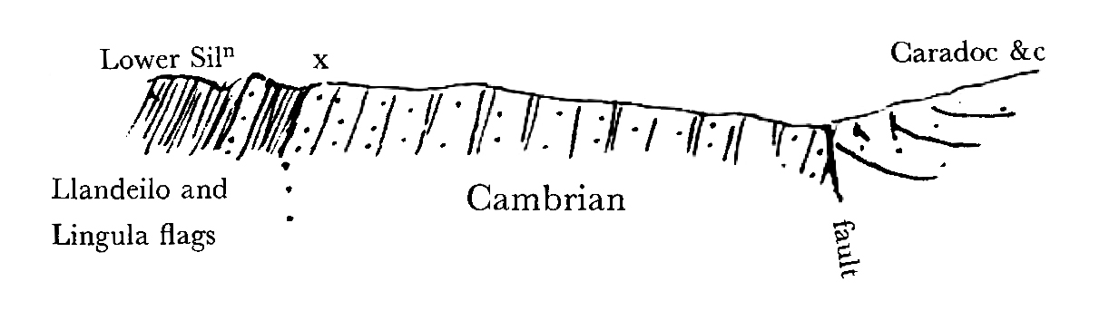 Dot the fault up at any reasonable angle & prolong the Silurian line x up to it & you get a fault of 100000 ft or so,3 under impossible conditions when all the Geology of the country is considered. Besides it is too big to be believed.
In North Wales the extreme thickness of the Cambrian is in Merionethshire about 7000, or 8000 feet, & then you do not get to the bottom.
In Merionethshire Selwyn makes the Lingula flags about 6000 ft. & it looks well.4 5000 might be I think safely taken.
11000 to 12000 for the Llandeilo & Bala or Caradoc beds
2000 ft of the Pentamerus or Llandovery beds, & Pale slate or Tarannon shale. (New names adopted by the Survey & Murchison, being sort of passage beds from Lower to Upper Silurian).5 I fear these are a great deal more in thickness in districts where they have not yet been properly tracked, & are likely to remain so.
Denbighshire flags at the base of the Wenlock shale 2000 feet Wenlock shale & lime 1800 ft Ludlow Rocks I think 3500, but I write from memory & may be far wrong. I think you will find it in De la Beches heavy memoir on the deposits of South Wales in the Survey Memoirs.6 We measured it together near Builth. Old Red Herefordshire 8000. I measured it myself.
There are no measurements in Devonshire that I ever heard of & I do not think they exist. Nor yet in Scotland. People have heretofore contented themselves with the words ‘prodigious, enormous, astounding’ & such like.
Carboniferous Limestone of S. Pembrokeshire, Gower &c, 2500 ft. I was at the measuring in Pembroke & in Glamorganshire it was done by Logan.7 Coal Measures of Glamorganshire by Logan doubtfully ranging between 12000 & 14000 ft. See (I think) De la Beches Memoir as above. In Nova Scotia at the South Joggins I think Logan & Dawson measured 14000 ft of Coal Measures.8
In S. Wales the Millstone grit is included in the C.M. It is 1000 ft where thickest.
The Permian of the Magnesian limestone districts, as far as I know is yet unmeasured. The Permian marl & conglomerates believed to be of Older date round the Central Coal fields from 800 to 1000 ft.
Sedgwick gives sinkings through the limestones for Coal.9 Phillips gives for it about 350 feet.10
In Thuringia near Eisenach I was at a place where they sank 2500 ft through the Rothtodteliegunde for Coal.11 20 miles off it was scarcely 20 ft thick.
Bunter sandstone of Central Counties 1500 ft & probably 2000 further north, the central beds being thick waterworn conglomerates of quartz & quartz rock.
Keuper Marl & Sandstone 1500 ft
Lias clay & lime, I have known them go 900 ft through it without getting to the bottom. None of our sections are so thick
Marlstone 150 feet
Upper Lias clay 200 feet Phillips
Sand (Lias Sand of Wright) See his paper in Geological Journal a year or two ago on Frocester Hill.12
Inferior Oolite Cheltenham 264 ft by Hull13
Fullers Earth 150–200?
Great Oolite—200?
Cornbrash— 40?
Oxford Clay 600
Coral reef 150?
Kimeridge clay 600?
Portland stone 100 ft
Purbeck?
Weald unknown.
Lr Greensand may be obtained from Bristows Isle of Wight sections.14
Gault 100 to 200 ft but said to be of much greater undetermined thickness N.E. of Oxford.
Upper Greensand 138 ft
Chalk 1200 ft. Probably more Tertiaries from Prestwich & Bristows Isle of Wight sections & Forbes Memoir on I. of W.15 This however will give no true idea of the London area.
Clay I know nothing about.
Drift gravel I know 200 ft of in Shropshire, & 600 ft of in the State of New York.
My memory fails me abt some of the Oolites, but it is to be got from some of our Survey sections, & I could get the thicknesses for you when I go to town or if you are in town & call Mr. Best will measure them for you.16
I must think about the faults & reply to that query again
Ever truly | Andw C Ramsay
CD annotations
Footnotes
Bibliography
Correspondence: The correspondence of Charles Darwin. Edited by Frederick Burkhardt et al. 29 vols to date. Cambridge: Cambridge University Press. 1985–.
Dawson, John William. 1855. Acadian geology: an account of the geological structure and mineral resources of Nova Scotia, and portions of the neighbouring provinces of British America. Edinburgh.
De la Beche, Henry Thomas. 1846. On the formation of the rocks of South Wales and south western England. Memoirs of the Geological Survey of Great Britain and of the Museum of Economic Geology in London 1: 1–296.
Flett, John Smith. 1937. The first hundred years of the Geological Survey of Great Britain. London: His Majesty’s Stationery Office.
Hull, Edward. 1857. Memoir of the geology of the country around Cheltenham. Memoirs of the Geological Survey of Great Britain and of the Museum of Practical Geology. (To accompany Sheet 44 of the Geological Survey.) London.
Origin: On the origin of species by means of natural selection, or the preservation of favoured races in the struggle for life. By Charles Darwin. London: John Murray. 1859.
Prestwich, Joseph. 1846. On the Tertiary or supracretaceous formations of the Isle of Wight as exhibited in the sections at Alum Bay and White Cliff Bay. Quarterly Journal of the Geological Society of London 2: 223–59.
Summary
Responds to CD’s queries about the thickness of various geological formations. [See Origin, p. 284.]
Letter details
- Letter no.
- DCP-LETT-2387
- From
- Andrew Crombie Ramsay
- To
- Charles Robert Darwin
- Sent from
- St Andrews
- Source of text
- DAR 205.9: 398
- Physical description
- ALS 8pp †
Please cite as
Darwin Correspondence Project, “Letter no. 2387,” accessed on 19 April 2024, https://www.darwinproject.ac.uk/letter/?docId=letters/DCP-LETT-2387.xml
Also published in The Correspondence of Charles Darwin, vol. 7